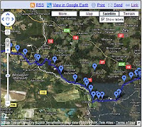
Click here to follow the route 12,000 Allied POWs took when they were forced to evacuate the German prisoner of war camp, Stalag Luft III, on the night of January 27, 1945, into the teeth of a raging blizzard. In a line stretching nearly 20 miles long, they were marched west 52 miles to Spremberg, Germany, where they were then crammed on box cars and transported to Stalag VII in Bavaria.
Click here to go to an interactive map where you can follow along the route we Kriegie Kids took as we retraced the steps of our fathers. When the map fully loads, you may use the zoom in/out tool, and you can left click and drag the map underneath you - but first click on the double [<<] at the top center of the map to clear the symbols on the left which will widen the map view. The journey begins in Poland at the eastern end of the map, at the site of Stalag Luft III, and ends in the German city of Spremberg at the train yards. Along the route are various pins that you can click on which will reveal interesting information and pictures. When you encounter a place on the map that has a lot of pins, zoom in further and further to spread the pins out and to get a better view of the land underneath. If you zoom in too far the resolution will fail. Have fun!! For a list of some of the Polish towns and their German names that were used during the war, use the "Read More" link below:
Here is the list of some of the Polish towns and their German names used during the war:
Zagan - Sagan
Czerna - Hammerfeld
Ilowa - Halbau
Borowe - Charlottenhof
Godznica - Freiwaldau
Lipna - Selingersruh
Przewoz - Priebus
Potok - Pattag
Tuesday, March 03, 2009
Subscribe to:
Post Comments (Atom)

No comments:
Post a Comment